10:00am - 11:30am
Question, Persuade, Refer (QPR) Suicide Prevention Training (Four Corners Health Department)
Ebenezer United Methodist Church, 12th & Road U, Rural Waco
10:30am - 11:30am
Kilgore Memorial Library
12:00pm - 1:00pm
12:00pm - 1:00pm
Noon Sertoma Club Meetings (Noon Sertoma Club)
Chances R
10:00am - 11:30am
Vintage Book Trees Classes (SCC York Learning Center)
SCC York Learning Center
12:00pm - 1:00pm
Rotary Club Meetings (Rotary Club)
Chances R
3:00pm - 5:00pm
5:30pm - 6:30pm
York City Council Meeting (City Council)
100 E. 4th Street, York, NE 68467; Council Chambers
6:00pm - 7:30pm
Vintage Book Trees Classes (SCC York Learning Center)
SCC York Learning Center
10:30am - 11:30am
Kilgore Memorial Library
6:00pm - 10:00pm
Believe Fundraiser (Emmanuel-Faith Lutheran School & Little Blessings Preschool)
Holthus Convention Center
1:00pm - 4:00pm
Lighted Cornhole Tournament (Renewed Horizon)
York City Auditorium
7:00am - 8:00am
Morning Sertoma Club Meetings (Morning Sertoma)
Wendy's
6:30pm - 8:00pm
Grief Share - New Heights Church
New Heights Church, 1522 S. Grant Ave. - York
6:30pm - 8:30pm
Grief Share Surviving the Holidays (New Heights Church)
New Heights Church
4:30pm - 5:30pm
York Creative District Advisory Board Meeting (York Creative District Advisory Board)
100 E. 4th Street, York, NE 68467; Council Chambers
7:00pm - 8:30pm
Healthy Dog Snacks Class (SCC York Learning Center)
SCC York Learning Center
10:30am - 11:30am
Kilgore Memorial Library
12:00pm - 1:00pm
Noon Sertoma Club Meetings (Noon Sertoma Club)
Chances R
6:30pm - 7:30pm
Lions Club Meeting (Lions Club)
Chances R - Shi-Ra Room
12:00pm - 1:00pm
Rotary Club Meetings (Rotary Club)
Chances R
9:30am - 5:30pm
10:30am - 11:30am
Kilgore Memorial Library
12:00pm - 1:00pm
Kilgore Memorial Library, 520 N Nebraska Avenue, York
4:00pm - 8:00pm
All Day
8:00am - 2:00pm
Small Business Saturday - at MCLEAN BEEF (McLean Beef)
McLean Beef
9:00am - 11:00am
YP -Small Business Saturday Meetup
Downtown
9:30am - 3:00pm
The Quilt Basket - Fat Quarter Frenzy
The Quilt Basket
10:00am - 12:00pm
Small Business Saturday - SANTA is HERE! (Wagner Decorating/Isaiah's Toybox)
Wagner Decorating
11:00am - 1:00pm
Small Business Saturday - $1 Movie (Sun Theatre)
Sun Theatre
City utility bills can now be paid online or by phone with no additional fee. Payment by bank withdrawal, by dropbox or in person are all still options as well.
Regardless of how you pay your bill - you can choose paperless billing.
Go to our online billing site to sign up for an account to set up paperless billing (Use Contact Preference) or to pay your utility bills online. As an added bonus, once you set up an account, you can easily see your utility usage and costs over several months with the dashboard function.
For Spanish language assistance with utility bills, pay by phone 833-441-1747
Online Payments: https://www.municipalonlinepayments.com/yorkne
Pay by phone: 833-441-1747
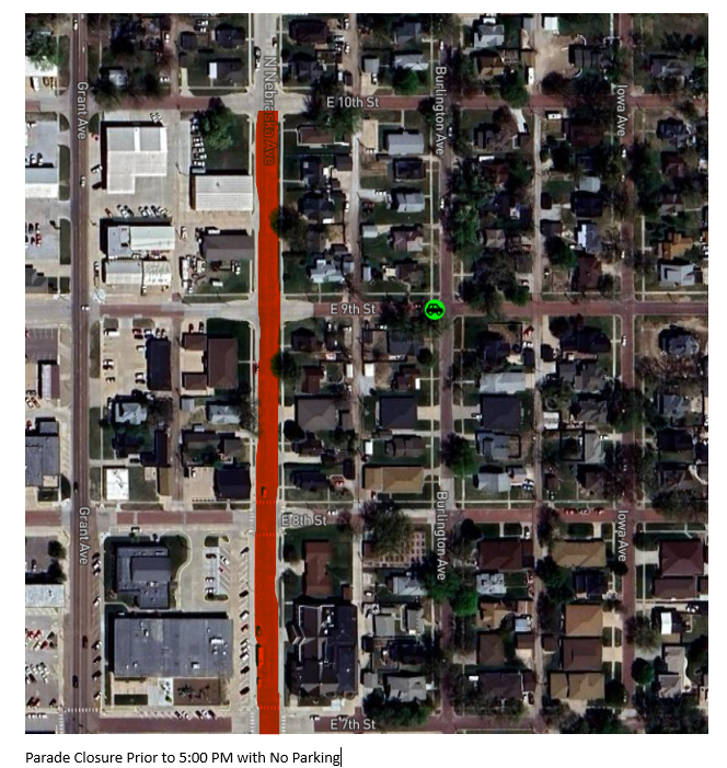
A house burn is scheduled for 10/26/2024. Please see the picture below for street closures and parking restrictions.
A reminder as we get into campaign, contractor, event, and garage sale season -
All yard signs must be placed on personal property. Generally this is the portion of the lawn behind the sidewalk. The area between the sidewalk and the street is city right-of-way. Signs are not allowed in the city right-of-way and may be removed.
The City of York worked with JEO Consulting to obtain floodplain revisions to pull several properties out of the floodplain in the northeast section of town. The floodplain areas in other parts of the community were not able to be adjusted.
To view the new Flood Insurance Rate Maps that have been issued for the City of York's jurisdiction, click here.
To toggle layers in the map on and off, click on the layers list icon on the left side of the screen.
Insurance Rating Options for Newly Mapped Areas
Map Changes and Flood Insurance - What Property Owners Need to Know
Below is a link to the Public Input Report.
Warning - it is over 500 pages -
PROJECT ACCESS YORK UPDATES
Project Access York Update - 09/11/2024
The City has been working with engineers and state transportation project team members to consider comments from community members submitted during the public comment period for Project Access York over the summer. The official responses to the comments have now been approved. Individual letters with an individual response to each individual who submitted comments through the process were sent out by mail on Friday, September 6.
An overview of the changes proposed based on the public feedback is summarized below. A full set of responses to the Frequently Asked Questions is provided below this summary.
What changes have been made to the project as a result of the public involvement process?
The project team reviewed all comments received from the public meeting on May 28th, 2024. The project team met and discussed the suggestions made within the comments and determined that the following changes, additions or revisions to the project could be incorporated into the project while still meeting the purpose and need of the project.
PROJECT ACCESS YORK FAQs
Updated August 19, 2024
What changes have been made to the project as a result of the public involvement process?
The project team reviewed all comments received from the public meeting on May 28th, 2024. The project team met and discussed the suggestions made within the comments and determined that the following changes, additions or revisions to the project could be incorporated into the project while still meeting the purpose and need of the project.
How is the trail going to be kept safe?
How may the trail affect my property?
To construct and maintain the trail, the proposed project would require permanent or temporary property rights in the form of ROW, permanent easements or temporary easements. ROW and easement acquisition would be managed by The Nebraska Department of Transportation (NDOT). Their general process is to perform an appraisal of the area of land that is to be acquired, contact the landowner for negotiations and process the acquisition of ROW or easements resulting in a payment to the property owner.
Will the trail have lighting?
Current cost estimates anticipate that lighting would only initially be included on the pedestrian bridge. As solar lighting technology improves, the cost and feasibility of including more lighting would be considered.
Will fencing be constructed along the trail?
Fencing may be included along certain segments of the trail. Properties that currently have fencing would be compensated through the ROW process for the removal and relocation of their fence to the new edge of their property line.
Who will maintain the trail and be liable for accidents on the trail?
The City of York (the City) would be responsible for trail maintenance (i.e., mowing, repairing, and removing snow) to ensure trail accessibility and to make the trail visually appealing. Liability for users who have accidents on the trail would be the responsibility of the City and in the City’s overall liability insurance policy.
How is cost being considered?
The current costs are estimates based on recent construction bid information and anticipated inflation with contingency cushions. The City would continue to work with the project team as design progresses to control costs.
Future maintenance, lighting, amenity or law enforcement costs are not included within the project estimate and would be the responsibility of various City departments depending on the future needs of the trail.
What is NDOT’s involvement in this project?
NDOT supports the proposed Project Access York project through many different roles, project coordination, National Environmental Policy Act (NEPA) reviews, permitting and procuring, and it is committed to working in partnership with the City to ensure the project adheres to regulations and requirements throughout the many different phases of the project lifecycle.
NDOT congratulates the City on its work to apply for and be awarded the $15 million in federal RAISE Grant funding for this project.
How was the bridge location chosen?
Multiple locations for the proposed pedestrian bridge over US-81 were evaluated early on in the design process. Four options were presented to the public in March of 2023 at the public open house between Noami/McGowan and 35th Street. Consensus from the public open house preferred a bridge location south of David Drive rather than north near 35th Street. Constructability, cost, and ramp locations were evaluated for locations south of David Drive. The location selected near Noami Road & McGowan Street provided the most technically feasible and cost-effective solution while placing access points to the bridge near high-pedestrian traffic areas. The ramps on either end of the bridge would be constructed to be ADA (American Disability Act) compliant. Stairs and/or elevators would not be included with the construction of the bridge.
What alternative routes have been explored for the southern portion of the trail and why weren’t alignments closer to Hwy 81 or Grant Avenue selected?
In March of 2023, the project team, in coordination with multiple community stakeholders, held a community day of planning called a design charrette. This design charrette was a day-long effort to build a preferred route for the proposed Project Access York project. During the design charrette, the project team reviewed the original alignment proposed under the Rebuilding American Infrastructure with Sustainability and Equity (RAISE) Grant with the group and discussed the purpose and need of the project for each segment of the trail. Multiple breakout groups collaborated on each section of the proposed alignment and presented their agreed upon route to the overall group. The entire group discussed, debated, and agreed on the alignment that would be carried forward into design, the preferred route. At the end of the day, each segment of the trail with the original and revised alignments were presented at a public information open house meeting.
The current alignment best meets the transportation criteria of safety, cost-effectiveness and benefit to the community expected to use the trails. The most important safety principle for trail design is reducing conflict points with traffic. The majority of crashes between bicyclists and vehicles occur at intersections and driveways (1). The route along the railroad right of way corridor provides long stretches of trail with no driveways or intersections. Any other route compromises safety by adding multiple additional driveways and/or intersections.
The current proposed route along the old railroad ROW corridor is preferred for additional reasons including:
The sections below outline the other routes explored along with additional the reasons why they were removed from consideration.
The original route proposed under the RAISE Grant along the east side of US-81/Lincoln Avenue between S 21st Street and Nobes Road was evaluated and removed from consideration for the following reasons:
Alternative routes along the east and west sides of Grant Avenue up to Nobes Road and over to Beaver Creek Park, as shown within the original RAISE Grant, were evaluated and removed from consideration for the following reasons:
A route along S 21st Street to Blackburn Avenue was additionally evaluated and removed from consideration for the following reasons:
A revised alternative alignment which diverts from the current proposed trail route just south of the church on the old railroad ROW and proceeds east to ultimately head north along the west side of Grant Avenue up to the currently proposed trail crossing of Grant Avenue near the Beaver Creek tributary was additionally evaluated and removed from consideration for the following reasons:
What about questions not listed here?
Not all feedback can be incorporated into the design of the project while still maintaining the purpose of the project and the key values of safety, cost effectiveness, and benefit to the community expected to use the trails. Connecting all parts of the city is the heart of the project and rationale for receiving the $15 million grant. As discussed in this FAQ, the railroad right of way corridor remains the best alignment based on the core values of safety, cost effectiveness and benefit to the community expected to use the trail. Each person who submitted a question or comment would receive an individual response to their question if they provided their contact information.
References